
VIENNA — The Clifty Creek Conservation Area and Clifty Creek Natural Area offer many recreational opportunities such as bird watching, fishing, hiking, hunting, outdoor photography, wildlife …
This item is available in full to subscribers.
We have recently launched a new and improved website. To continue reading, you will need to either log into your subscriber account, or purchase a new subscription.
If you are a current print subscriber, you can set up a free website account by clicking here.
Otherwise, click here to view your options for subscribing.
Please log in to continue |
|
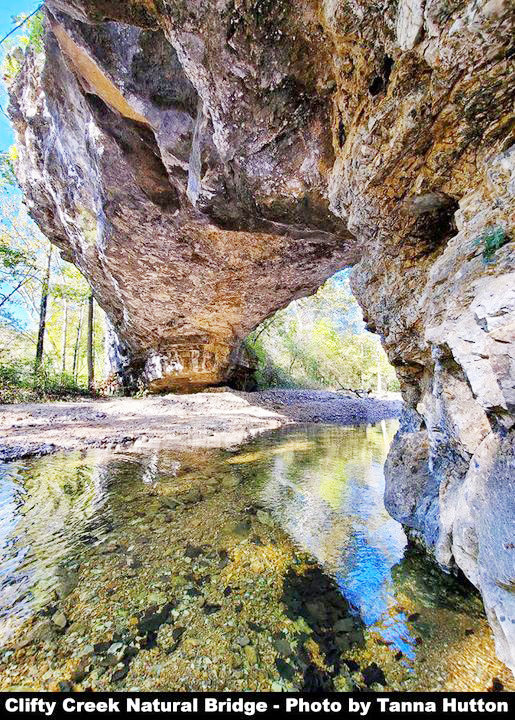
VIENNA — The Clifty Creek Conservation Area and Clifty Creek Natural Area offer many recreational opportunities such as bird watching, fishing, hiking, hunting, outdoor photography, wildlife viewing and camping.
Clifty Creek Conservation Area and Clifty Creek Natural Area are adjacent to one another and combined offer the public 486 acres in Maries County to enjoy. These areas are located at the end of Highway W, six miles northeast of Dixon.
Due to the rugged terrain in this part of the state, much of this area has seen little change since settlement times and due to the lack of fire has developed into an overstocked forest, according to the Missouri Department of Conservation. Settlers found only the extreme southern and a few northern portions of the area level enough for cultivation. A six-car parking lot for the area is found on MCR 511.
In 1984, the Donald Walker Trust donated 156 acres to the Conservation Department, which later purchased 100 additional acres to form the conservation area. The conservation area and the adjacent Clifty Creek Natural Area, owned by the LAD Foundation, provide crucial watershed protection for Clifty and Little Clifty creeks which run through the areas.
One of the more dramatic features of Clifty Creek Natural Area is a natural bridge with a spin of about 40 feet that was created by a tributary of Clifty Creek carving through Gasconade dolomite.
The areas also contain oak-hickory forest, mixed bottomland forest, limestone glades and cliffs and sandstone glades.
A very scenic 2.5 mile loop hiking trail leads from the conservation area parking lot to the natural bridge and back. A hiker can choose to take the loop or can choose to go and come from the arch via the same trail portion. The trail has an intersection one-tenth of a mile from the parking lot. The right fork in the trail is an additional one mile to the area; if hikers choose the left fork the arch is 1.4 miles away, one way. Both forks are very scenic and traverse some very interesting natural features.
This trail was completed in the fall of 2008, through funding from the Conservation Department, the Missouri Conservation Heritage Foundation, the LAD Foundation and the Department of Natural Resources via the Recreational Trails Program of the federal government. In addition to these contributors, volunteers from around the state built the trail entirely by hand.
A hiker should have appropriate foot wear, water and be in good enough physical condition to walk the moderately difficult trail. The difference in elevation from the parking lot to the bottom of the arch is about 200 feet, however, due to the terrain, the change in elevation exceeds 200 feet as the hiker moves up and down the lay of the land in route to the arch.
The areas are open to public use from 4 a.m. to 10 p.m.